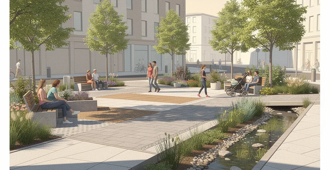
Public space is the connective tissue of a town or city. Streets, squares, parks and civic plazas shape how people move, meet and feel about the place they live in, and their design has a measurable effect on wellbeing, safety and local economic vitality. For local authorities, improving public realm is rarely about a single grand gesture; it is the product of established placemaking theory, statutory planning frameworks, climate-resilient infrastructure, inclusive design standards and genuine community engagement working together. This article sets out the principles, policy tools and delivery lessons that councils across the UK are using to create public spaces that function well, look good and last. It draws on established urban design thinking alongside practical case studies and current national planning guidance, offering a grounded reference point for officers, councillors and design teams involved in shaping the public realm.
Placemaking principles that underpin successful public space design
Good public space design does not start with materials or planting schemes. It starts with a clear understanding of how people actually use a place, what draws them to it, and what keeps them away. Several established frameworks help translate that understanding into design decisions.
Jan gehl’s Human-Scale urbanism and the 12 quality criteria
Jan Gehl’s approach to urban design is built on a simple premise: cities should be designed for people first, not for vehicles or abstract masterplanning diagrams. His method assesses public space against criteria grouped around protection (from traffic, crime and unpleasant weather), comfort (opportunities to walk, stand, sit, see and talk) and enjoyment (human scale and positive sensory experience). The practical value of this approach lies in its insistence on observing how people behave in a space before redesigning it — watching where they linger, where they cut corners, and where they avoid going at all. Councils applying this thinking tend to prioritise slower traffic speeds, generous footways, sheltered seating and active building frontages that keep streets feeling occupied and safe throughout the day.
Kevin lynch’s legibility framework: paths, nodes and landmarks
Kevin Lynch’s work on urban legibility addresses a different but related problem: how easily people can understand and navigate a place. His framework identifies paths (the routes people travel), edges (boundaries between areas), districts (recognisable zones with a shared character), nodes (points of activity or decision-making, such as junctions or squares) and landmarks (distinctive reference points). A legible town centre or neighbourhood allows people to orient themselves intuitively, which reduces anxiety, supports independent movement for older people and children, and encourages exploration on foot. This concept aligns closely with the emphasis on legibility found in national design guidance, which highlights the importance of views, vistas and landmarks in helping people find their way around new developments.
Project for public spaces (PPS) and the power of 10+ methodology
The Project for Public Spaces approach argues that successful cities are built from a critical mass of good public spaces rather than one flagship project. The « Power of 10 » principle suggests that if a neighbourhood offers ten good destinations, it reaches a critical mass capable of attracting a diverse range of people; extend that logic and a city with ten such neighbourhoods gives every resident access to outstanding public space within reach of home. PPS also promotes a « lighter, quicker, cheaper » philosophy: rather than committing to expensive, fixed interventions from the outset, councils are encouraged to test improvements — seating, markets, temporary planting, painted crosswalks — and refine them based on how people respond. This experimental, iterative approach reduces the risk of costly mistakes and allows a public space to evolve organically over time, as demonstrated in projects ranging from market redesigns in Durban to neighbourhood festivals in Gyumri, Armenia.
Biophilic design strategies for urban greening
Integrating nature into public space is no longer treated as decorative; it is a functional requirement. Street trees, planting, and water features contribute to biodiversity, manage drainage, and moderate microclimate, while also making streets more comfortable and attractive to use. National design guidance is explicit that natural features should be integrated into a multifunctional network supporting quality of place, biodiversity, water management and climate resilience, with priority given to ensuring diverse ecosystems can flourish. Beyond ecological benefit, exposure to greenery and well-maintained landscape has a direct bearing on how safe and welcoming a space feels, encouraging the physical activity and social interaction that underpin healthier communities.
Statutory planning frameworks and design codes shaping local authority decisions
Placemaking theory only becomes deliverable when it is embedded in the statutory planning system. UK local authorities work within a hierarchy of national guidance, funding mechanisms and local policy that together determine what gets built and how.
National design guide and national model design code compliance
The National Design Guide sets out the Government’s priorities for well-designed places through ten characteristics: context, identity, built form, movement, nature, public spaces, uses, homes and buildings, resources, and lifespan. It makes clear that creating high-quality buildings and places is fundamental to what the planning and development process should achieve, and that permission should be refused for development of poor design that fails to take opportunities to improve the character and quality of an area. The guide should be read alongside the National Model Design Code and Guidance Notes for Design Codes, which provide more detailed parameters for the physical development of a site or area. For councils, this means public realm proposals are increasingly expected to demonstrate a clear design narrative — often through a Design and Access Statement — showing how a scheme responds to local context, history and character rather than applying generic templates.
Section 106 agreements and community infrastructure levy funding
Delivering high-quality public space costs money, and much of that funding is secured through developer contributions negotiated as part of the planning process. These mechanisms allow councils to require or fund improvements to streets, parks and public infrastructure as a condition of granting permission for new development, ensuring that growth pays towards the public realm it relies on and the additional demand it creates. Effective use of these tools depends on councils having a clear, evidenced public space strategy in place, so that contributions are directed towards genuine local priorities rather than piecemeal or reactive spending.
Building for a healthy life standards applied to public realm projects
Building for a Healthy Life is a widely used tool for assessing whether new development creates places that support health and wellbeing, and its principles overlap significantly with the National Design Guide’s characteristics. Applied to public realm projects, this means testing whether streets prioritise walking and cycling, whether public spaces are overlooked and feel safe, and whether a genuine mix of uses supports everyday activity throughout the day. Local authorities increasingly use such standards as a reference point during design review, helping planning officers and councillors assess schemes against a consistent, evidence-based framework rather than subjective judgement alone.
Local plan policy integration with supplementary planning documents
Local Plans provide the strategic policy basis for how an area will grow, but the detailed expression of design expectations often sits in Supplementary Planning Documents, local design guides or design codes. The National Design Guide is explicit that specific, detailed and measurable criteria for good design are most appropriately set out at the local level, whether through local design policies, design guides or codes prepared by local authorities or by applicants themselves. This layered approach allows councils to translate national priorities into guidance that reflects local vernacular, landscape character and community priorities, giving both officers and developers a clearer basis for negotiation and decision-making.
Sustainable urban drainage systems and Climate-Resilient infrastructure
Public realm design is increasingly expected to do more than look attractive; it must also help manage flood risk, moderate temperature extremes and support long-term climate resilience.
Suds hierarchy: swales, rain gardens and permeable paving
Sustainable drainage systems are designed to reduce flood risk by capturing and managing surface water close to where it falls, using features such as swales, rain gardens, permeable surfaces, retention ponds and green roofs. National design guidance describes these as forming an integrated system of landscape, biodiversity and drainage, working alongside existing watercourses to create multifunctional « green » drainage networks that also enhance the attractiveness of open spaces and provide opportunities for play, interaction and relaxation. Well-designed public spaces build in sustainable drainage systems to manage surface water, flood risk and significant changes in rainfall, making use of green sustainable drainage and natural flood resilience wherever possible.
Urban heat island mitigation through strategic tree canopy cover
Hard, built-up urban environments absorb and retain heat, creating an « urban heat island » effect whereby temperatures in dense areas are noticeably higher than surrounding countryside. Deciduous trees provide shade to buildings and public spaces, helping manage solar gain during summer months and reducing this effect, while also improving air quality and mitigating pollution. Councils looking to build climate resilience into their public realm should treat tree canopy cover not as an aesthetic afterthought but as functional infrastructure, planned alongside seating, water features and shelter to keep streets and squares usable during periods of extreme heat.
Flood risk management in waterfront regeneration schemes
Where public realm schemes sit close to rivers, canals or coastal edges, flood risk management becomes a defining design constraint rather than a secondary consideration. Some places are designed to adapt to flood conditions directly — for example, a terraced open space where lower levels double as a water feature during high water, or buildings with habitable rooms raised above flood level. Waterfront regeneration therefore requires early collaboration between planners, drainage engineers and landscape architects to ensure that public space remains attractive and usable in normal conditions while also performing a genuine flood management function when needed.
Case studies from UK councils delivering transformative public realm schemes
Theory and policy only prove their worth when tested against real delivery. Several UK schemes illustrate both the opportunities and the pitfalls of ambitious public realm transformation.
Exhibition road, kensington and the shared space model
Exhibition Road in Kensington is one of the UK’s best-known examples of the shared space model, in which the traditional separation between carriageway and pavement is removed or blurred, encouraging drivers, cyclists and pedestrians to negotiate space more cautiously and on more equal terms. The design uses a distinctive checkerboard paving pattern and minimal kerb delineation to create a single, continuous surface across the street’s width. Schemes of this type require particularly careful consideration of the needs of visually impaired and other vulnerable users, since removing conventional kerb lines can remove cues that pedestrians with sight loss rely on — a tension that has shaped subsequent guidance on shared space design nationally.
Sheffield’s grey to green infrastructure retrofit
Sheffield’s Grey to Green project converted underused road space into a linear sustainable drainage corridor, replacing hard carriageway with planting, swales and pedestrian and cycle routes. The scheme demonstrates how sustainable drainage principles can be retrofitted into an existing urban street pattern rather than only being applied to new development, turning a former traffic-dominated route into green infrastructure that manages surface water while creating a more attractive, walkable environment through the city centre.
Manchester’s piccadilly gardens redesign and public consultation lessons
Piccadilly Gardens has been through repeated cycles of redesign, reflecting the difficulty of reconciling competing demands on a single, highly visible civic space — transport interchange, green space, event venue and gathering point. The scheme’s history offers a useful lesson for other authorities: public realm projects that do not engage residents and stakeholders thoroughly from the outset risk producing spaces that fail to build the sense of ownership needed for long-term success, regardless of the quality of the physical design itself.
Coventry’s city centre south regeneration under UK city of culture investment
Coventry’s city centre regeneration, accelerated by investment linked to its UK City of Culture status, illustrates how a heritage-led approach to town centre renewal can combine sensitive re-use of existing structures with new public realm investment. This reflects a wider principle in current practice: repurposing existing buildings and spaces, rather than defaulting to demolition and rebuild, can add richness and variety to a scheme while contributing positively to net zero ambitions by reducing embodied carbon.
Inclusive design and accessibility standards for streetscapes
A public space cannot be considered well designed if it excludes significant groups of users. Accessibility standards and universal design principles should be treated as a baseline requirement, not an optional enhancement.
BS 8300 compliance and universal design principles
Universal design principles require that public spaces be designed from the outset to be usable by the widest possible range of people, including those with physical disabilities, sensory impairments or reduced mobility, without the need for later retrofitting or special adaptation. This means careful attention to gradients, surface materials, seating provision, crossing points and rest opportunities along any pedestrian route. National design guidance reinforces this principle by defining inclusion as making sure all individuals have equal access, opportunity and dignity in the use of the built environment — a standard that should shape decisions from the earliest design stage rather than being addressed as an afterthought.
Tactile paving, dropped kerbs and wayfinding for visually impaired users
Physical features such as tactile paving and dropped kerbs give visually impaired pedestrians critical information about changes in level, the presence of a crossing point, or the boundary between footway and carriageway. This is particularly important in shared space schemes, where the removal of conventional kerb lines can otherwise strip away cues that many disabled pedestrians rely on. Effective wayfinding — through clear signage, consistent street furniture positioning and legible route structures — supports independent movement for people with visual or cognitive impairments and complements the broader legibility principles set out by Kevin Lynch’s framework.
Age-friendly city design following WHO guidelines
An ageing population is one of the demographic shifts explicitly identified as shaping the future of place design. Age-friendly public realm means providing frequent, well-placed seating, avoiding excessively long distances between rest points, ensuring good lighting, and designing crossings with sufficient time and clear sightlines. National guidance recognises the need to address the needs of an ageing population as a core objective of good design, alongside providing a range of housing and community facilities — such as extra-care housing, independent living schemes and age-restricted housing — that are well integrated with public transport and local services, rather than isolated from everyday community life.
Community engagement methodologies for Co-Designing civic space
Community involvement is not simply good practice; the evidence suggests it materially affects whether a public space succeeds. People who help shape a space are more likely to feel ownership over it, use it, and care for its upkeep over time.
Participatory budgeting models used by local authorities
Participatory budgeting gives residents direct influence over how a defined pool of public funding is spent, often through a voting process on competing proposals for local improvements. Mexico’s national Rescue of Public Spaces programme offers a relevant international example: since 2007, the country’s Ministry of Social Development has « rescued » tens of thousands of public spaces by combining physical works with social action, explicitly aiming to promote community organisation and participation, increase safety, and strengthen a sense of belonging in marginalised urban areas. The underlying principle — that community organisation and participation drive both the design and the long-term success of an intervention — applies equally to smaller-scale participatory budgeting exercises run by UK councils.
Charrette workshops and design review panels
Intensive, collaborative design workshops — often referred to as charrettes — bring together residents, technical experts and decision-makers over a concentrated period to develop and test design options together. This kind of structured engagement was central to the approach used in Design Council’s work with local authorities on economic growth and regeneration challenges, where teams used design tools such as challenge statements, stakeholder mapping and vision posters to build a shared understanding of a problem before developing solutions. As one participating officer observed of this design-led process:
Inception is the phase where the project is less defined and there is a temptation to jump forward to an answer. The design-led process helps to define and consider challenges and outcomes more fully.
Design review panels, meanwhile, provide an independent check on scheme quality at key stages, testing proposals against agreed design principles before they proceed to detailed design or construction — reducing the risk of costly problems emerging only after a scheme is built.
Digital consultation platforms such as commonplace and bang the table
Online consultation platforms allow councils to gather structured feedback from a wider and more representative cross-section of residents than traditional public meetings typically reach, including people who cannot attend in-person events due to work, caring responsibilities or mobility constraints. These tools can combine interactive mapping, surveys and open comment threads to capture both quantitative preferences and qualitative local knowledge. Used well, digital consultation complements rather than replaces in-person engagement such as charrettes, giving councils a fuller picture of community priorities before committing to a final public realm design.